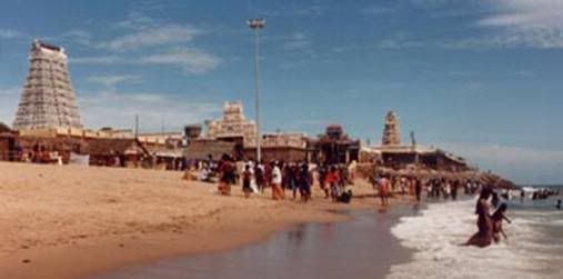
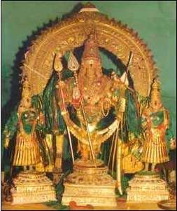
Temple of lord Murugan at Tiruchendur which is very close to the sea shore

Tiruchendur Lord Murugan Temple is on the sea shore - within 100 metres of the waves.
The Temple is a cave with the entrance at the sea level and the cave inside, slides down to the Sanctum Sanctorum of the Lord Subramaniam ( Murugan ) .
When we stand in front of the deity, the sea water level outside is higher than our heads. So, there is every likely hood that tidal waves and tsunamis can rush in and fill the cave Temple with sea water. According to the history of the Temple, it is mentioned that the Water God ( Lord Varuna ) has promised Lord Murugan that he will not cross the boundary of the Temple.
On TSUNAMI day
It seems the Water God has kept his promise. While the tsunami on 26/12/04 lashed the eastern coast of India and inundated all places near the coast deeply, the sea water did not enter the Temple. At 10.00 Hrs on the ill-fated day ( 26/12/04), the sea near the temple receded by a Kilometre - people could see a big crater there with many rocks visible - gradually the sea came back to its original level. But sea water entered Jeeva Nager located opposite Tiruchendur Bus stand at 12.30 Hrs.
All other coastal areas near Tiruchendur were affected by the lashing of tsunami. But, the Temple area is unaffected as the sea receded there as though to keep the promise given.


9 comments:
kanthanuku arogara !!
Very Nice,
vetrivel veeravel
Murugan is great, he has saved me frm so many obsctacles. He knows the truth and had given the best that suits me
Fabulous post.OM MURUGA...
Fabulous post...OM MURUGA
Really nice information in this article.Tiruchendur is one of the famous temple city in south tamilnadu.and we are collecting all over information in Tiruchendur.Its the one stop website for all information in tiruchendur.best jewelers,schools,colleges,agencies…
FAKE FAKE FAKE!!
The first thing we did was to confirm that the timings in your mail are right. This was done by comparing them with the tide-gauge record at Tuticorin (seehttp://www.nio.org). The tsunami's first blow was at 1000 hrs and coincided with low tide. Immediately after the water rose above the tide, there was a regress. The next peak, almost as high as the first because the tide was coming in by then, was around 1230 hrs. These are the two timings we have from your mail. In the first report, water regressed "by a km" near the temple; in the second, it entered Jeeva Nagar, which is located near the bus stand.
The second thing we did was to discuss (with our Tiruchendur colleague) the local topography and the normal behaviour at these two locations during high and low tide. He confirms that the high tide never affects the temple, but the bus stand is often flooded. He and his friends, who used to go to the bus stand area to play cricket, would have to return because of the water-logging. Since he says "often", not "always", we assume that the cricket was affected only during the spring high tide, which occurs on full and new moon days. (A bus stand would not be functional if it flooded every day by the high tide, but flooding once a fortnight might be tolerated.)
The third thing we checked (with our Tiruchendur colleague) is if a promontory exists in the area. (A promontory is a cape-like structure jutting out of the coast.) After some thought, he confirmed that there is such a feature in the local coast, and that the bus stand is located on the south of the promontory and the temple is on the north.
We now have with us all that we need to explain what has been observed. First, unless the tsunami was very big at Tiruchendur, and the tide-gauge record at nearby Tuticorin confirms it was not (thanks to Sri Lanka, which saved the Gulf-of-Mannar coast of TN by taking the direct hit), it was unlikely to affect the temple because the tide also does not affect it. The tsunami affected the bus stand and Jeeva Nagar, but this is a normal phenomenon there. Second, like the tide, the tsunami came into the Gulf of Mannar from the south. The local topography of the continental shelf (the shallow part of the seas as one goes away from the coast) and the local beach (or coastal) geography has a major effect on the way a tsunami affects the coast. The promontory acts (our feeling, but note that this is based on deductions without any "hard" surveys and high-resolution numerical simulations) as a barrier and this saved the temple on the north of the promontory. The bus stand on the south face of the promontory, however, was in the line of fire and took a heavier (am I right?) blow than it does during the spring high tide. There may be more to the topography, than we can judge sitting here, that saved the temple.
I will be surprised (judging by the Tuticorin record), however, if the bus stand was dry after 1000 hrs. The second peak may have brought in more seawater, but it also should have seen some ingress during the first peak at 1000 hrs, following which there would have been a regress, maybe drying the bus stand in the process.
We now come to something not as mundane. It is likely that Lord Varuna, when he made the promise to Lord Murugan, added a fine print: "This protection is valid only if you stay put in this place". Had Lord Murugan decided to move to Jeeva Nagar, the promise very likely would have been rendered invalid by divine law.
@Anonymous.
Thank you! Need more people like you.
Your explanation is valid
Post a Comment